Showing posts with label river. Show all posts

Tuesday, July 23, 2024

A Sunrise Walk Down the Matsuura River


Monday, March 24th, 2014, and I take the first train out of Sasebo heading north.


The sun comes up as I am approaching Hizen Nagano from where I will continue on with day 72 of my walk along the Kyushu pilgrimage.


These very early morning walks are often one of the highlights of these walks I do.


Heading north along the Matsuura River, the valley is initially covered in a mist which somehow makes the light very bright. A white light rather than the warm yellow of sunrise light.


The Matsuura River starts in the mountains near Arita and heads roughly north until reaching the sea at Karatsu, my destination for the day.


Though there is a railway line running down the river valley, there are no big settlements, and nothing of note to visit until I reach Ochi, about two hours later.


Here I will have to head up a tributary of the main river to visit the first pilgrimage temple of the day.


The previous post was on my visit to Sasebo port the evening before.


Wednesday, January 3, 2024

Crossing the Yodo River


As day 2 of my walk along the Kinki Fudo Myo pilgrimage winds down it was time to head west after visiting the cluster of temples in central Osaka.


I crossed the Yodo River on the bridge that carries Route 2, a non-descript low, concrete bridge, one of 70 that crosses the Yodo.


At this point the river is about 600 meters wide. It starts 70 kilometers away inLlake Biwa and there it is called the Seta River. When it crosses into Kyoto it becomes the Uji River, and south of Kyoto it is joined by the Katsura and Kizu rivers and changes its name to Yodo.


Before the advent of the railways in the modern period it was the main transportation artery between Osaka and the capital in Kyoto.


Looking back, the high-rise landscape of downtown Osaka dominates.


The previous post in the series was on the Yasaka Shrine on the East bank.


Tuesday, June 6, 2023

Urauchi River & Mariudo Falls


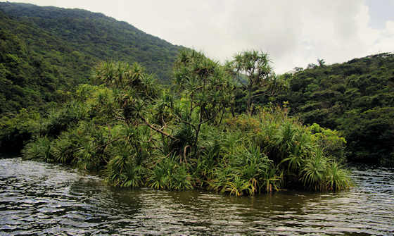
The Urauchi River is the longest river in Okinawa Prefecture, and it is found on Iriomote Island, the largest of the Yaeyama Islands.


As Okinawa consists of many small islands, its perhaps not surprising that the longest river is only just over 18km in length.


the river source is in the middle of the mostly uninhabited island at 311 meters elevation and reaches the sea at the NW of the island.


Boat trips go upriver about 10 kilometers and from where they stop a trail runs another kilometer or so to Mariudo Falls.


A three stage falls of just 16 meters, Mariudo Falls is not the tallest on Iriomote, but possibly the most visited. It is possible to hike further upstream to another waterfall, and several smaller falls are passed on the way to Mariudo.


Many sources use the word "jungle" to describe Iriomote, but while it is certainly different from mainland Japan, I would use "sub-tropical" forest.


What Iriomote does have is plenty of mangroves, trees that grow in the salty water of intertidal zones in tropical and sub-tropical environments.


The guide on the boat was very excited to point out this bird which, I believe, was a Crested Sea Eagle.


Its also possible to cruise the river in guided kayak tours.


The previous post on Okinawa was on Mount Nosokodake on neighboring Ishigaki Island.

Monday, May 1, 2023

To Kawahira


At the far end of Tanomura, the almost-deserted settlement on the right bank of the Gonokawa River, is a small shrine hidden back where the former farmland meets the hillside, the kind of location where people built their homes. According to  Google Maps, it is no longer marked as a shrine. Not sure what criteria they are using, but the shrine still stands but has probably not seen a ceremony in quite a few years.


It was an Omoto shrine I believe, and the doors were unlocked, something normal for shrines in the countryside I think. The structure hanging from the ceiling is a tengai, under which kagura was performed. About 6 to 8 years ago I stopped in and everything was just about as it is now. Probably there were a few more inhabitants back then. Not sure what the Japanese equivalent of deconsecration is, but the shrine may not have been used, but is still technically a shrine, so I find google maps to be less and less accurate and truthful


It's about halfway between what used to be the previous and next stations and I doubt anyone from Tanomura ever used the train in the past twenty years.


From here there are no settlements until Kawahira. No solitary farmhouses or isolated rice paddies. The narrow road and former train line cling to the edge of the steep slopes.


On the opposite bank, there is a main road and a lot more settlements. Also, lots of construction work building up embankments and raising the level of the road to counter the increasing floods Quite a lot of brand new houses are built to replace those demolished for the "improvements".


About twenty years ago I floated down the river on a Dragon Boat and from down at the waters level you could barely ever see the roads or any man-made structures...... I think the new construction is changing that.


Before coming into Kawahira a small roadside Buddhist shrine......... It has seen better days, but someone comes from some distance away sometimes to give it a sweep and to add green offerings..... i suspect a very elderly person, and in all likelihood when they pass away there will be no one left to remember the story and history behind this little altar


The previous post in this series following my walk up the Gonokawa River to its source was Around the Next Bend.

Sunday, September 9, 2018

Nobeoka to Hyuga City


Sunday, March 24th, 2018, was the 19th day of my walk around Kyushu on the 108 temple Shingon Pilgrimage. The route from Nobeoka down to Hyuga City included only one temple of the pilgrimage, but lots of small shrines to stop in at and explore.


It was a relatively uneventful day with no major discoveries on my part, though I enjoyed the visits to the shrines as for me there is almost always something to see.


On my way down the coast I crossed many rivers and though it was an overcast day and not great for photography light-wise, it was a still day so the water was mirrorlike.


More palm trees appeared so it certainly felt like I was now in Miyazaki. I stopped early in the day as I had reached the hotel I had a room booked in. The view from my room was not particularly great.


Tuesday, August 7, 2018

Down the Kitagawa


I started my 18th day along the Kyushu Pilgrimage just across the border into Miyazaki. I started to follow one of the branches of the Kitagawa River as it flowed downhill towards Nobeoka. Walking long distances in japan means either walking the coastline which is relatively flat, or following a river up to a pass and then down the other side...... the path of least climbing.


For much of the year mist clings to the mountainsides and fills river valleys, and today was no exception. There are probably dozens of Kitagawa Rivers in Japan..... the name simple means North River. Most family names in Japan are derived from locations, so Kitagawa is a fairly common family name..... the most famous that springs to my mind being Kitagawa Utamaro, the famous Edo Period artist.


As is the nature of rivers, as one descends the route becomes less steep, the river larger, and the valley wider.....


The mist was at times so thick the sun became white. By lunchtime I was down much closer to sea level, the mist had long since burned off, I pass where a larger branch of the river joined up, and traffic had increased.


Friday, August 3, 2018

South from Saiki: Day 17 of my walk around the Kyushu Pilgrimage


heading south out of Saiki, my next stop would be Nobeoka, and I had a couple of choices of route. Probably the prettiest would be the coast road, but I opted for the inland route over the mountains, pretty much following the rail line, as it would save me 20k. I left at sunrise.


The route went upstream one of the tributaries of the Banjo River. There was nothing of note along the route that I planned to visit.


I stopped in at a couple of interesting looking temples, and quite a lot of shrines.


Pointing to some kind of forest park, this giant Stag Beetle was a curious sight. It was still the height of the cherry blossom season. By sunset I had gone over the pass and was on my way down the Kitagawa River which would take me all the way to Nobeoka.