Showing posts with label sanbe. Show all posts

Monday, December 11, 2017

Iwami Kannon Pilgrimage Day 3

Iwami Kannon


Sunday 16th December 2012, and I begin my third day walking the Iwami Kannon Pilgrimage with Mount Sanbe silhouetted  inland. Today I will walk from Shizuma down the coast and end at Nima.


There was one of the pilgrimage temples and lots of shrines.  A few mountain roads and a few villages and a nice stretch of beach to walk.


A great day for surfing, I guess,.... we get good surf mostly in the winter it seems.


A couple of the shrines are very intriguing and tell the story of the arrival of Susano from the Korean peninsula. Almost completely ignored in most renditions of the myths and early history of Japan, the two shrines were instrumental in sending me on the search for Susano stories...

Saturday, September 6, 2014

Ascending Sanbesan


iw7381

Towards the end of the first day of my walk along the Iwami 33 Kannon Pilgrimage I was close to the base of Mount Sanbe. It had taken me all day to walk more than 20k from Oda City and had climbed about 500 meters. My plan was to meet a friend on top of Sanbe to spend the night, so another 600 meters of climbing to go.

iw7384

I was going up by the most travelled trail on the northern slope. Since leaving Oda there had been no stores, convenient or otherwise, but in the recreation area at the base of the mountain was a Sanbe Burger. The only Sanbe Burger on the planet I believe. Late on a Friday afternoon in early November I was the only customer. After filling my belly I headed off with some trepidation. I don't like climbing! I'd been walking all day and was tired, but to get from a to b in Japan you are going to have to climb some.

iw7388

At 500 meters plus there was still a lot of green, but the color change was starting.

iw7390

Higher still, most of the green had gone, save for the moss.

iw7393

Higher still and the light was fading, and then suddenly I was on top. I was really surprised. It was easier than I had expected. Maybe I have gotten better at pacing myself. I certainly haven't gotten any younger. A couple of minutes after reaching the summit young Wes appeared having come up by a different trail.

iw7395

My posts on the sunset and the next days sunrise can be found below this post.

Wes's account can be found here.

Thursday, August 8, 2013

Sanbe Dam


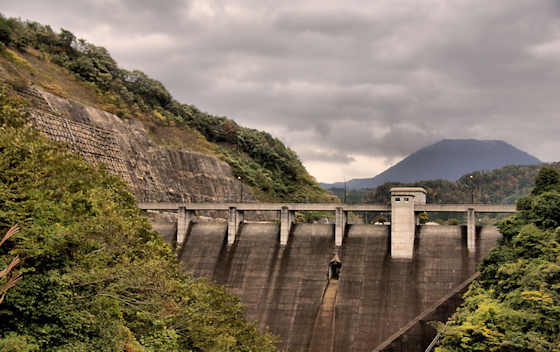
The second temple on the Iwami 33 Kannon pilgrimage (actually the first "extra" temple) is located on the mountainside above Sanbe Dam. Thats Mount Sanbe behind.


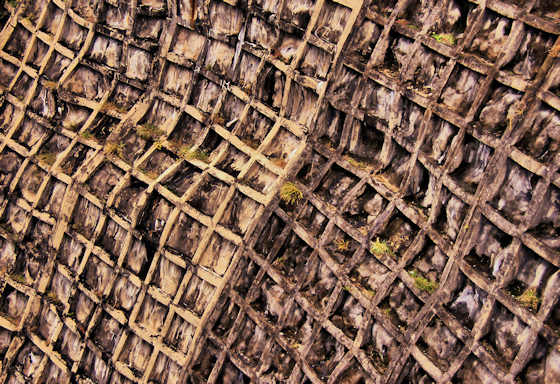
Seeing how aged the concrete is I was surprised to learn that the dam was not finished until 1996, although construction started in 1980.


The dam is a little over 54 meters high and 140 meters wide at its crest and is composed of 110,000 cubic meters of rock and concrete. Ostensibly the purpose of the dam is flood control and to supply water to Oda City, but its real purpose is to funnel money to construction companies.


The small reservoir has a capacity of 7,000,000 cubic meters of water.


Saturday, November 24, 2012

More Sanbe Sunrise


iw7428

I couldn't resist posting some more photos from my recent night on Mount Sanbe.

iw7453

The earlier posts are here and here...

iw7470

Turns out this is my 999th post!!!!

iw7496

iw7514

Sunday, November 4, 2012

Sunrise on Sanbe


iw7427

It was a cold and windy night with lots of rain, sleet, and snow, but with the coming of the sun the wind swept the clouds off the mountain top to reveal the view....

iw7439

Off to the north Izumo and the mountains north of Izumo taisha were clearly visible...

iw7450

To the east the valleys were still filled with clouds and mist.... known as unkai in Japanese...

iw7457

To the west the onshore winds had not yet cleared the clouds away...

iw7465

Somewhere down in the SW near the horizon was my village..... with the sun the fall colors cloaking the mountain were finally visible....

iw7520

Saturday, November 3, 2012

Sunset on Sanbe


iw7307

On Thursday I started walking the Iwami 33 Kannon pilgrimage. The second and third temples lie around the base of Mount Sanbe (1126m) so I decided to make the detour and climb to the top as it had been some years since I was up there. I started out in Oda just slightly above sea level and the route took me along the river directly towards Sanbe some 20k distant.

iw7402

It was a mostly overcast and showery day and I got to the top about 4:30 and off to the west the clouds cracked open to reveal a splash of color....

iw7405

About 2 minutes later Wes of Hiking in Japan arrived at the top and we took a few photos before the clouds closed and settled on the mountain. 2 minutes after that it started to rain and kept up all night long becoming sleet and snow at times. Fortunately there was a hut to take shelter in....

iw7407

Sunday, April 17, 2011

The view from Sanbe

m34

Sanbe San is the name given to the highest point in Shimane, a cluster of 7 peaks.

!,126 meters above sea level, I have only climbed it one time.

m37

Most people go up it on the trail on the north side but I went up a barely used trail on the south side.

m39

As you would expect there are some great views once you get out of the trees.

m41


m42

In the distance the Shimane Hanto with Izumo Taisha at its base.

According to the Kunibiki myth the peninsular was dragged from Sila and held to the land of izumo by a rope that is now the beach you can just see. The other end of the peninsular was tied by a rope to Daisen in Tottori.

m44

A huge caldera.

Thursday, March 3, 2011

Sanbe San

oda784

This is the draincover for the town of Oda, a fairly nondescript town close to the border between Iwami and Izumo. The mountains in the background are known as Sanbesan, and are the highest in Shimane at 1,126 m above sea level.

Oda does not have much to see for tourists, and is pretty much just the rail access point for visitors to the nearby World Heritage site of Iwami Ginzan, but I did wander around last fall hunting the fall colors.

maru7

This view of Sanbesan is from near my house, and must be about 25k distant as the crow flies. I took the photo on a winter walk up Maruyama.

s1501

On the lower slopes. Sanbesan is actually a cluster of 7 volcanoes, and the highest one is named Osanbesan. We were on our way to visit the Buried Forest Museum, actually a fascinating place where you can go below ground and see 4,000 year old trees that were buried in a major eruption.

m31

This is on the south side, and its where I slept out before climbing to the top early the next morning. I had walked two days from my house to get here. One of these days I will write up that walk :)

Thursday, May 27, 2010

A winter walk up Maruyama

maru3

Driving from my place to Iwami Ginzan, which I used to do regularly a few years ago, you pass through the village of Mihara, and as one is doing so the 480 meter high Maruyama (Round Mountain) is distinctly visible for quite a ways.

One fine January day the weather was warm and the light was bright so I decided to to find out what the views were like from the top.

I drove up the long, narrow valley that runs up from Tanijyugo, parked and headed up the forest track that climbed over the ridge and dropped down to the base of Maruyama.

maru6

Half way up Maruyama there was a clearing in the trees that offered a wonderful view over Mihara to the saddle of the ridge called Oe-Takayama. The highest point is a little over 800 meters, and behind it lies Iwami Ginzan. According to a painted signboard in the village at its base, there is a trail that goes up and along the ridge that I've always hoped to climb one day, though I suspect that the trail, like so many others around here, has long since disappeared by not having been used for decades.

maru8

The road up to the top of Maruyama switchbacks up the north side, so there was still unmelted snow.

maru12

Just below the highest point are the foundations of what used to be a castle, though fort or watchtower might be a more appropriate english word.

maru11

From the top, the view roughly south. Somewhere down in there is the Gonokawa River and my village.

maru10

But this is the view I had hoped to find. About 25k away, the snowy peaks of the volcano Mount Sanbe, at 1,126 meters the highest point in Iwami.

Tuesday, December 8, 2009

Concrete wabi sabi: more steps.

Continuing with my exploration of the aesthetic potential in Japan's favorite material,.... more steps!

An Afternoon Around Sanbe Dam4128

An Escheresque view of the steps down sanbe Dam.

4feb4326

A very standard form of steps. These go down to the stream that run through Omori, Iwami Ginzan.

m1383

Of course concrete can be poured into any shape. These curved steps go down to the boat dock for the horikawa boat tour on the river in Matsue.

tam3419

These lead down to a hot spring in the river at Tamatsukuri Onsen.

sh468

I really liked these that lead up into the Museum of Ehime History & Culture.

seoul4961

These last ones are not actually in Japan, but Seoul, Korea.