Friday, October 13, 2023

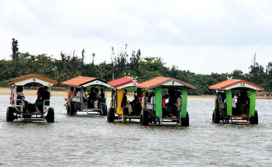
Yubu Island Water Buffalo Carts


Yubu is a tine island 400 meters off the coast or Iriomote Island that has no ferries or bridge.


Transport to and from the island is by carts pulled by water buffalo, or by walking.


The island was formed by  deposits from the Yonara River and so is only just 1 meter above sea level. At high tide the channel is only 1 meter at the deepest point, and at lower tides is much shallower.


A line of utility poles marke the route for pedestrians and carts.


Very much a touristy thing, the drivers typically play sanshin and sing Okinawan folk songs.


Most of the island is a botanical garden. The island was settled after WWII but most left after a devastating typhoon of 1969.


The previous post was Iriomote Island Snapshots. An earlier post on Taketomi Island Water Buffalo Carts.


Thursday, October 12, 2023

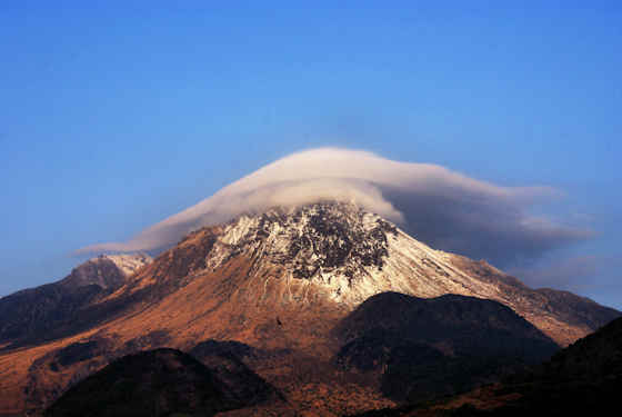
Mount Unzen


Mount Unzen is a group of volcanoes in the middle of the Shimabara Peninsula in Nagasaki, Kyushu.


The highest point is Heisei-shinzan at 1483 meters, but the main peak is Fugen-dake, but the eruptions of 1990 to 1995 made Heisei-shinzan higher.


Mount Unzen is clearly visible from most parts of the Shimabara Peninsula and even further afield.


When I visited on February 20th, 2014, on day 62 of my first walk around Kyushu, a dusting of snow made Unzen strikingly clear.


Before heading over the mountains to the other side of the peninsula I headed south a little to visit a few sites connected to the major eruptions of the 1990's.


The previous post was my diary of day 61.

Wednesday, October 11, 2023

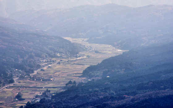
Views From Mount Futago


At 720 mteres, 2,364 ft, above sea level, Mount Futago is the highest point of the Kunisaki Peninsula in northern Oita, Kyushu.


On clear days, looking north past Homeshima Island, the coast of Honshu can be seen.


Like much of Japan, the Kunisaki Peninsula was formed by volcanic activity, and in essence is a lava plateau with a lava dome in its centre with multiple volcanoes. It was formed between 1 and 2 million years ago.


Erosion has left many cliffs and rock formations that can be seen from the top of Mount Futago.


The peninsula is roughly circular with Mount Futago at the centre. Radiating out are 28 valleys that became home to a unique religious culture known as Rokugo Manzan.


Rokugo Manzan incorporated Tendai Buddhism with Usa Hachiman "shinto" into a unique form of shugendo. Shugendo ascetics, known as yamabushi, were often attracted to such powerful geological features.


I had climbed up from Futago-ji Temple, now the head temple of Rokugo Manzan, located on the lower slopes of Mount Futago. I had spent all day walking up from near Kitsuki on the southern edge of the peninsula. My plan was to keep walking until I hit the ferry port on the northern coast.


Tuesday, October 10, 2023

Kyushu Pilgrimage Day 61 Nagasato to Shimabara


Wednesday February 19th 2014.

I catch the first train out of Nagasaki to Nagasato and the sun is up by the time I start walking. The mountaintops to the north are white with snow but down here on the coast the wind is a little crisp but its blowing away the low clouds to reveal a blue sky mottled with high cloud. After a short walk I come to a road that is most unusual in Japan..... its is dead straight for 7 kilometers. Reason being it is on a dyke that stretches across the bay to the far shore.


This is the infamous Isahaya BayReclamation Project, a 2 billion dollar boondoggle that has destroyed the last major tidal wetlands in Japan. The rationale for its construction was to “reclaim” land to grow rice, but by the time it was completed in 1997 Japan had masses of unused agricultural land and farmers were being paid to not grow rice. Once the water stopped flowing out into the Ariake Sea the life of the wetlands began to disappear and the fishermen and nori harvesters of the Ariake Sea started to report reduced yields. As far as I know, there is currently a gridlock because of lawsuits of environmentalists and fishermen on the one hand who want the dike opening up, and those with a vested interest in the reclaimed land who want it to stay closed.


Halfway across the dike is a rest area and I am able to climb up for a bit of a view, to the south is the Shimabara Peninsula with Mount Unzen rising in the middle. All being well I will be walking over those mountains tomorrow. The long, straight slog across the mouth of the bay on top of the dyke was uneventful. I now follow the coast road east and then south. Whenever I get the chance I take detours away from the nosy and busy main road and stop in and explore shrines.


By late morning I am coming in to Kumini and here I cut inland to visit somewhere I discovered while exploring with Google Maps. Its an old “samurai district”, a collection of old samurai dwelling and walled streets dating back to the Edo Period. While the walls lining the streets still exist, many of the houses are of much more recent vintage, though there are a few old ones. The centerpiece however is the Nabeshima House, built by a lesser member of the family that ruled over what is now Saga, though Kunimni is now Nagasaki. Unfortunately, the main house is closed to the public while it is undergoing some renovation work, but the gardens were a pleasant surprise.


I wander back to the main road and continue down the coast when I start to see streetlamps shaped like crabs holding a soccer ball. Then I saw a giant version????? what the hell is that all about? Have they trained a species of giant crab to play soccer? Or is it that crab is the local specialty and the local high school soccer team often wins the national championships?


By now the coast road is running south and as one of the bright yellow local trains trundles by I contemplate hopping on for the last section down into Shimabara, but it has turned out to be a beautiful day with a clear blue sky so I ignore my legs grumblings and carry on walking.


I got into town and my booked hotel room as the sun had disappeared behind Mount Unzen but it was still light enough to explore some shrines near my hotel.


Day 60 around Nagasaki was the previous diary post.


Sunday, October 8, 2023

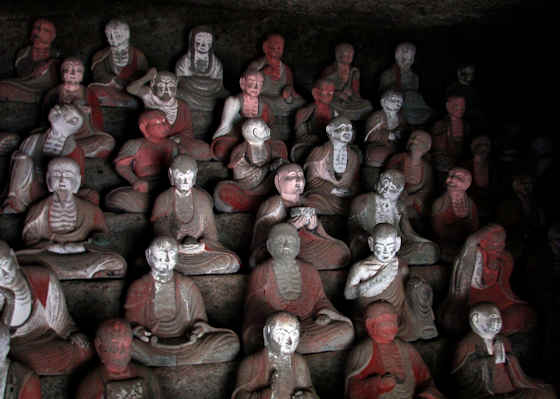
500 Rakan at Iwami Ginzan


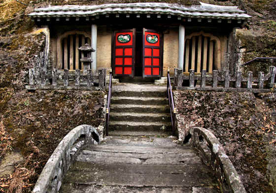
Rakan, sometimes called arhats, are said to be the disciples of the historical Buddha, and groups of 500 statues representing them can be found all over Japan.


The collection of 500 rakan found in Omori, part of Iwami Ginzan Silver Mine, is unusual in that they are housed in several man-made caves dug into a hillside by miners working at the silver mine.


The rakan here at Iwami Ginzan were made to pray for the repose of the souls of those miners who died, and as the work was brutal and harsh, the life of a miner was usually quite short, which is why there were so many temples in the area.


One feature of Rakan is that every single one has a different features and expressions, and it is often said that while looking at rakan statues you will always find some that remind you of someone you know. The rakan here are included in the UNESCO World Heritage Site.


All the rakan here were made over a period of about 25 years and were completed in 1766. They were all attributed to a stonemason from nearby Fukumitsu with the pseudonym Toshitada, who is also credited with creating the 3 arched bridges that cross the stream to reach the rakan caves. It is thought that members of his family and other apprentices had a hand in the work


Rakan-ji Temple was established across from the rakan caves in 1764. It is a Shingon temple and the honzon is an Amida. A Yakushi hall was moved to the grounds from higher up in the valley.


Rakanji Temple is one of 10 "guest temples" on the Iwami Kannon Pilgrimage. Kannon pilgrimages usually have 36 main temples and a few "extra" temples, but this Iwami pilgrimage has a total of 49 temples so is often referred to as Iwami Mandala Pilgrimage.


The previous post in this series was Seisuiji Temple, located further up the valley closer to the mine. A recent post that also featured rakan statues  was Togakuji Temple in Matsue.


Saturday, October 7, 2023

Reikyu Shrine Shimabara


Reikyu Shrine is located in Reikyu Park in the  Bentenmachi district of Shimabara City in Nagasaki.


The park also contains a small Inari Shrine, a Steam locomotive, and a nice pond garden.


It was originally founded in the mid 17th century by Koriki Tadafusa  who had been given control of the domain following the Shimabara Rebellion.


In the grounds is a Senryosono Shrine, pictured above, but there is no information on the shrines history or the kami.


Initially Reikyu Shrine was a Toshogu, a branch of the Tokugawa mausoleum at Nikko that enshrines Tokugawa Ieyasu.


In the late 19th century the shrine name was changed to Reikyu and the seven generations of Matsudaira lords who ruled the domain following the Koriki, were enshrined here.


Also enshrined at the same time was the Munakata kami and Inari.


The previous post in this series on Day 61 of my Kyushu walk was on the Nabeshima Mansion Garden, further north on the peninsula.


Friday, October 6, 2023

Hata Shrine Nagahama


Hata Shrine in Nagahama, Kochi, is located right next door to Sekkeiji Temple, number 33 on the famed Shikoku Pilgrimage, and in fact is built on the site where the temple stood until it was destroyed in the anti-Buddhism campaigns of early Meiji.


Sekkeiji was the family temple of the Chosokabe Clan, and Motochika Chosokabe is buried there. He was the warlord who "unified" Shikoku under his control in the late 16th Century, and his name is familiar to most pilgrims because so many of the temples on the pilgrimage were burned down in his wars of conquest.


Hata Shrine was established in 1888 on the site of the destroyed temple to enshrine Motochika himself, and so in a sense is very much a political site, and as such seems sterile...... though maybe I am projecting. The name Hata was used as the Chosokabe claim descent from the famous Hata Clan of ancient Japan.


A small torii and path lead from the main shrine up on to the hilltop above where there is a small Nishinomiya Shrine dedicated to Ebisu. It is built on the site of what was Nagahama Castle, a very small castle that was the site of Motochika's first battle .


The previous post in this series documenting my walk along the Shikoku Pilgrimage was on the ferry that crosses Urado Bay on the route between Zenjibuji Temple, and Sekkeiji Temple.