Thursday, November 16, 2023
Exploring the Kuniga Coast
Wednesday, November 15, 2023
Kyushu Pilgrimage Day 63 Obama to Nagasaki
Friday February 21st 2014
The sun may or may not be up as I head out of Obama and take the road north along the coast of Tachibana Bay. Looming over the town the massive Mount Unzen blocks any view of the sun until later in the morning. Looking back, plumes of steam rise from among the buildings, a signature of an onsen town. Tachibana Bay is calm and a little darker shade of blue than the sky. A thin line of even darker blue shows the far shore dividing the two expanses of blue.
After half an hour I am able to veer off the main road and take route 201 which was once a railway line. I come to a fork just outside the first fishing village. My map says to take the right fork which starts to rise. My natural inclination is to take the lower road that will hug the coast, but I defer to my map. The road climbs gently and gives a nice overview over the village below and then passes through a narrow tunnel with the distinctive horseshoe shape of a railway tunnel
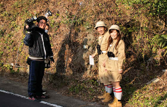
Coming out of the tunnel I come upon what I presume to be a local TV station making a travel program. An older man and a younger woman are both dressed in khaki shorts and wearing pith helmets. I resist the urge to shout out “Doctor Livingstone I presume!”. With only a cameraman and a sound man as crew, I am presuming they are a low budget local TV show something along the lines of “Lets Explore Locally”, because the next section of the road is a minor tourist attraction known as the Green Tunnel. The road, formerly the railway track, passes through a narrow cutting and the trees growing above have spread their canopy over the narrow cutting thereby creating a “green tunnel”. The road curves around the mountainside passing through several more tunnels.
At several points, there are great views down onto fishing villages below and along the approaching north shore of the bay. The road starts to descend as slowly as it ascended and I end up in Chijiwa where the main road now heads west towards Nagasaki. I find a convenience store to stock up at and sit with a coffee and check my maps. I want to avoid the main road if I can. I find a coast road that literally runs between the cliffs and the sea. Perfect. There is no traffic save for the occasional k-truck. The road comes to an end at a small onsen located right on the beach. From here there is no easy way along the coast so I head inland and join up with the main road heading to Nagasaki.
The road is fairly busy and at first there is a sidewalk, but as it leaves the village the sidewalk ends but starts again at the next village. The road is windy and goes up and down, though never steeply, and because of this the view changes often. I am surprised by the number of love hotels around. It is still about 30 kilometers to Nagasaki, but it is about halfway between Nagasaki and Isahaya, so maybe they serve both populations. Its a fairly uneventful afternoon with a couple of shrine visits, but as the traffic increases closer to Nagasaki it become less enjoyable.
By late afternoon I have covered 30 kilometers but there is still more than 10 to go and I think maybe 40k is too much. In the summer, with the longish days, 40k is doable, but at this time of the year it is just too much so I check the timetable at the next bus stop and finding a bus imminent I decide to take it. Tomorrow I head home. This leg has seen me cover 190 kilometers, making a total of 1,710 kilometers in total.
Tuesday, November 14, 2023
Wakaura Tenmangu Shrine
Sunday, November 12, 2023
Former Obama Railway
Saturday, November 11, 2023
Along the River to Tazu
Friday, November 10, 2023
Across & Over Shimabara Peninsula Day 62 Kyushu Pilgrimage
A Walk Around Kyushu
Day 62 Shimabara to Obama
Thursday February 20th 2014
I'm up early to another fine day with clear blue skies, though the peak of Mount Unzen is draped with a cap of clouds clinging to the snow on the peak. I will be passing over that range today so I set off early. First I head a little south to the UnzenDisaster Memorial Museum that commemorates the most recent eruption of Unzen back in 1996. I had been here before, and it is way too early for it to be open, but near the museum proper is another site that I had missed before. Many of the houses that were buried underthe mudslide are on display, some outdoors, some in a covered building. They actually look very weird because they have no damage, they are just buried with roofs and telegraph poles sticking out. Apparently, the mudflow, formed out of a mixture of ash and the extra runoff from heavy rains falling on the fresh lava, was only moving at a slow rate by the time it got here to the coast so people were able to evacuate slowly and safely, and the force of the flow was not strong enough to demolish the houses, just engulf them. All a bit surreal.
It turns out that the western slope of Unzen is much steeper than the eastern. There is no gentler slope as it gets further down, it is switchbacks all the way. I soon catch glimpses of Tachibana Bay through the trees, and there is less traffic on this side, so its a very pleasant walk. About three quarters of the way down I pass through a small settlement, the first since leaving the top. Some of the residents are out playing gateball, a Japanese variation on croquet and very popular with retirees.
A little further and I come to something quite unexpected and not marked on my map, some sort of a miniature religious theme park with the name Inori no Sato. There are no religious buildings, just a small tea room, but scattered around the grounds is a veritable who's who of popular Japanese deities. There are large statues of the Seven Lucky Gods, an Amida Buddha, several Kannon, a dragon holding a giant golden sphere, a Fudo MyoO, a kappa, a giant red Tengu mask, a small Inari shrine, and several others.
Thursday, November 9, 2023
Weeping Cherry of Senjuin Temple


